Albuquerque, NM – New Mexico is facing back-to-back winter storms, with the first system moving through the state Wednesday night and a second, colder storm expected to arrive late Thursday, bringing lower snow levels, heavier snowfall, and sharply colder temperatures through Friday. Weather officials say impacts will be felt statewide, with the most significant effects in western and northern New Mexico.
Winter Storm Warnings and Winter Weather Advisories remain in effect for several mountain regions as residents prepare for changing conditions, hazardous travel, and the coldest air of the season so far.
First Winter Storm Moving Through Wednesday Night
The first of the two winter storms began impacting New Mexico on Wednesday, bringing rain to lower elevations and snow to higher terrain, particularly across western and northern portions of the state.
Snow levels with this initial system are generally above 5,500 feet, allowing rain to fall across much of the lowlands while the mountains continue to accumulate snow. Officials say rain and snow will persist through Wednesday night, with most of the moisture from this system expected to wrap up by around 7 a.m. Thursday.
Mountain areas impacted by this first storm include:
- Western and northern New Mexico ranges
- The Sandia Mountains
- The Manzano Mountains
- The Sacramento Mountains
A Winter Storm Warning is also in effect along the Continental Divide in western New Mexico, including portions of Interstate 40, where snow-covered roads and reduced visibility are possible.
Brief Lull Before Second Storm Arrives
After the first system moves out, spotty rain and snow are expected to linger across western and northern New Mexico through Thursday morning and early afternoon. This brief break will be short-lived.
Meteorologists say the second and more impactful storm will begin moving into the state late Thursday afternoon and evening, bringing a surge of colder air and a rapid change in precipitation type.
Second Storm Brings Colder Air and Lower Snow Levels
The second winter storm is expected to arrive with a strong cold front, causing temperatures to plummet quickly across much of New Mexico.
A burst of rain and snow is likely to reach the Albuquerque Metro area around 6 p.m. Thursday, with snow levels dropping to around 6,000 feet. Forecasters say this could result in:
- Snow in parts of the Metro
- Rain and graupel down to valley floors
Across western and northern New Mexico, precipitation with the second storm is expected to fall primarily as snow, as temperatures drop rapidly. Light snow will continue wrapping around the system Thursday night.
Friday Impacts and Blowing Snow Concerns
A backdoor cold front will increase snow intensity and coverage across northeast and east-central New Mexico early Friday morning. Lingering snow showers are expected to continue across central, northern, and eastern New Mexico throughout Friday.
Officials warn that blowing snow will be possible, especially in northeast New Mexico, where gusty winds and falling snow could significantly reduce visibility and create hazardous travel conditions.
Snowfall Totals by Elevation
Forecasters say the heaviest snowfall is expected in the Gila region, where Whitewater Baldy could receive as much as 24 inches of snow.
Elsewhere across the state, projected snowfall amounts include:
- 6 inches or more above 8,000 feet
- 1 to 5 inches between 6,000 and 8,000 feet
- A dusting to 2 inches down to valley floors
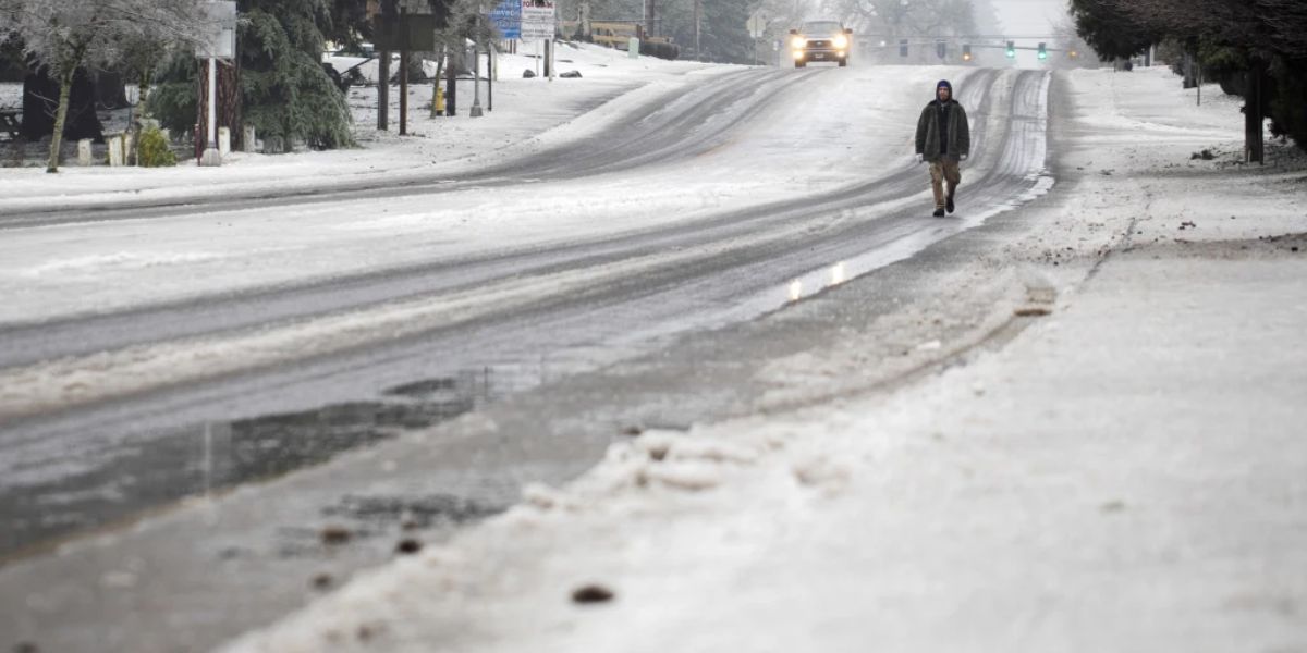
Snow accumulation combined with falling temperatures may lead to icy roads, especially overnight and during the Friday morning commute.
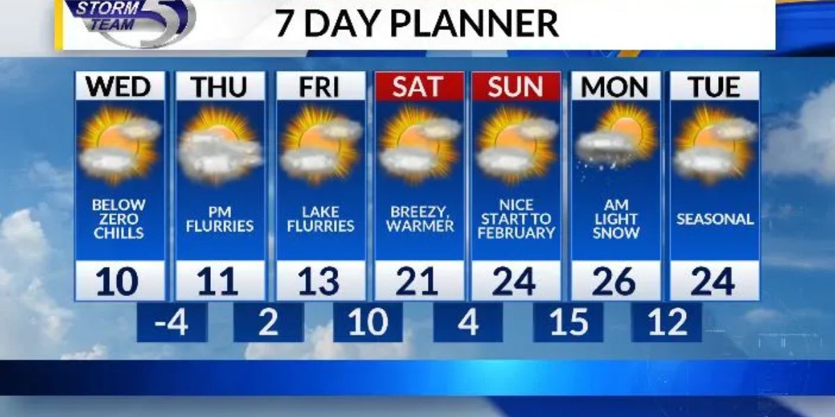
Bitter Cold Settles in This Weekend
Following the passage of the second storm, bitterly cold air is expected to settle across New Mexico by Saturday morning, bringing the coldest temperatures of the season so far.
High temperatures on Saturday are forecast to remain below average statewide, even as a gradual warming trend begins. Conditions are expected to improve by Sunday, with highs returning closer to seasonal norms and drier weather holding into next week.
New Mexico’s two-storm winter pattern will bring significant mountain snow, colder air, and travel challenges through Friday, followed by the coldest air of the season heading into Saturday. While conditions begin to improve late in the weekend, residents are urged to stay weather-aware and take precautions during this active winter stretch.
Share your experiences in the comments below.