Baltimore, MD — A stretch of early spring-like warmth will continue across the Mid-Atlantic through the end of the workweek, but forecasters say the mild pattern is temporary. Wet weather, a strong cold front, and a sharp drop back to winter temperatures are expected to impact Maryland and the surrounding region heading into the weekend.
Mild Late-Week Pattern Settles In
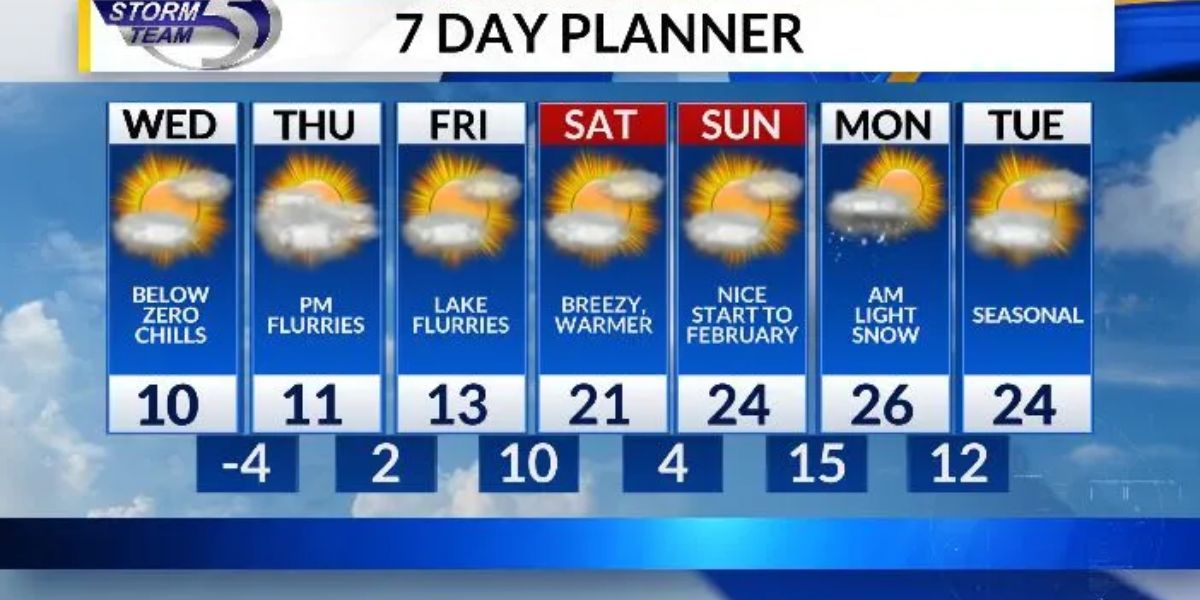
A warming trend remains firmly in place across Maryland as southerly winds pull in milder air from the south. Gusty breezes lingered through Wednesday afternoon before easing during the evening as a weak front slipped through the state. While slightly cooler air follows behind that boundary, temperatures on Thursday are still expected to climb above seasonal averages.
Highs on Thursday afternoon are forecast to reach the mid to upper 50s across much of the state, with sunshine mixing with passing clouds. Western Maryland may hold onto thicker cloud cover at times, but even there, temperatures remain unseasonably mild for mid-January.
The warm-up continues into Friday and Saturday as the next and more impactful cold front approaches. Forecast models show many neighborhoods warming into the 60s both afternoons, a notable departure from typical winter conditions. Forecasters say this type of warmth can be deceptive, especially with a significant pattern change waiting just ahead.
Rain Moves In Late Friday, Continues Saturday
Dry conditions are expected to hold through Friday morning for most of the state, though spotty showers remain possible late Thursday into early Friday, particularly in western Maryland. By Friday evening, rain chances increase from southwest to northeast as moisture surges ahead of the approaching front.
Rain becomes more widespread and steady Friday night, setting the stage for a soggy start to Saturday. Forecasters say a steady morning rain Saturday will transition to scattered showers by the afternoon as the front slowly pushes east. By the time precipitation tapers off later Saturday, many locations could record more than half an inch of rainfall, with a few communities approaching one inch.
Meteorologists note the rain will be beneficial, helping to ease dry conditions and wash away salt buildup on roads and sidewalks left behind by earlier winter weather. However, periods of steady rain may still impact travel and outdoor plans, prompting the possibility of a First Alert Weather Day on Saturday.
Drivers are urged to use caution during heavier rain, especially at night, when visibility may be reduced and water can pool on roadways.
Strong Cold Front Brings Wind and Winter Chill
Behind the rain, a strong cold front will usher in a dramatic change on Sunday. Temperatures will struggle to warm, with afternoon highs peaking only in the low to mid-40s across much of Maryland. Gusty northwest winds will make it feel even colder, with wind gusts of 30 to 40 mph expected statewide.
In higher elevations, winds could gust as high as 50 mph, increasing the risk of downed tree limbs and making travel more difficult for high-profile vehicles. The combination of falling temperatures and strong winds will mark a sharp contrast to the mild conditions experienced just days earlier.
Forecasters say the pattern favors continued cold air moving into next week, with the potential for additional winter or wintry-mix weather as new systems move through the region.
What Residents Should Know
The quick swing from warm, wet conditions to colder, windy weather can catch people off guard. Officials recommend keeping rain gear handy for Friday night and Saturday, then preparing winter coats and layers again for Sunday. Secure loose outdoor items ahead of strong winds, and stay alert for updated forecasts as the timing and impacts of the front become clearer.
With changing conditions expected over a short period of time, checking local forecasts frequently will be important for anyone traveling or making weekend plans.
Share your experiences in the comments below.