Memphis, TN – A pair of powerful cross-country storms is set to bring widespread heavy rain, severe weather, and flash flooding risks to large portions of the United States this week. The systems, moving in quick succession, are expected to impact millions of residents east of the Mississippi River while posing a heightened risk of severe storms in the central and southern U.S., and potential weekend washouts in the mid-Atlantic and Northeast.
Thursday: First Storm Moves East
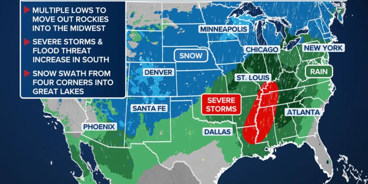
The initial storm system emerged Thursday from the Four Corners region and began its rapid eastward track. Early impacts were felt across Oklahoma, Missouri, and Kansas, where heavy downpours developed during the morning hours.
As the system progresses through the Midwest, rain is expected to cover Chicagoland, Illinois, Wisconsin, and Indiana, reaching portions of the Ohio Valley by Thursday evening.
In addition to heavy rain, a round of thunderstorms may develop across the Mississippi River Valley, stretching from St. Louis to Oklahoma City and as far south as Monroe, Louisiana. Forecasters warn that damaging wind gusts will be the primary threat, but brief tornadoes cannot be ruled out if storms cluster into fast-moving lines.
Friday: Severe Weather Threat Expands in the Deep South
A cold front associated with the first storm will enter the Deep South on Friday, creating the potential for the week’s most significant severe weather. The NOAA Storm Prediction Center has issued a Level 2 out of 5 risk for severe thunderstorms affecting more than 8 million people in areas including west Tennessee, Arkansas, Mississippi, Alabama, and Louisiana, covering cities such as Memphis, Jackson, and Baton Rouge.
These storms could produce damaging winds, hail, and isolated tornadoes, with the potential to impact homes, roadways, and outdoor activities across the region.
Meanwhile, the second cross-country storm will redevelop over the Four Corners and southern Rockies, bringing a second round of rain to many of the same areas affected by the first system in the Midwest and Mississippi Valley.
Flash Flood Concerns
The combination of these two systems raises the risk of flash flooding, particularly across middle Tennessee, Mississippi, and northern Alabama. The NOAA Weather Prediction Center has issued a Level 2 out of 4 flash flood threat, with 2 to 3 inches of rain expected, and localized pockets receiving up to 5 inches. Residents in flood-prone areas are advised to monitor waterways, avoid low-lying roads, and be prepared for rapid rises in water levels.
Northeast and Mid-Atlantic Rain
Rain from the first storm will spread into the Northeast and New England Friday morning, impacting Washington, DC, Philadelphia, New York City, and Boston. Showers are expected to linger through Saturday morning as the second storm shifts into the Great Lakes region.
While the Southeast contends with thunderstorms, showers will persist along much of the Northeast and New England coast, creating wet conditions for travel and outdoor plans.
Weekend Outlook
Conditions are expected to improve by late Sunday, with most areas drying out by Monday. Temperatures will remain slightly above normal through the event, but residents should anticipate widespread rain, gusty winds, and localized flooding through the weekend.
Safety and Preparedness Tips
Officials encourage the public to:
- Stay weather-aware via local alerts and NOAA updates.
- Avoid driving through flooded roads or low-lying areas.
- Secure outdoor belongings to prevent wind damage.
- Plan travel carefully, especially Friday through Saturday, in areas expecting the heaviest rain.
With two consecutive storms impacting much of the nation, communities are urged to remain vigilant as these systems unfold.
Share your experiences in the comments below.